

 |
|
|||||||||||||||||||
 |
|||||||||||||||||||
19th Street Reconfiguration
Click on photo to view full size
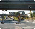 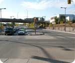 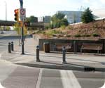 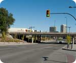 The entire redevelopment of our riverfront area in the downtown was guided by the South Downtown Concept Plan which was developed in 2004. In assessing the many existing issues, the Plan noted that the conditions of 19th Street, between 1st Avenue and Avenue A, were a significant impediment for east-west and north-south pedestrian and vehicle movement: “Currently 19th Street runs under the old rail bridge located between Idylwyld and the 1st Avenue on-ramp. This is an unpleasant area in which to walk or travel by bike, it feels unsafe at night. The sidewalks feel uncomfortably close to traffic under the bridge. Sight lines are poor for drivers and, perceptually, the area acts as a barrier between east and west.” To address these issues, the Concept Plan called for the removal of the rail bridge and the construction of a new east-west walkway on the south side of 19th Street. The new path would be designed to take pedestrians directly into the market square adjacent to the Farmers' Market. In the longer term, the Concept Plan suggested a higher-level footbridge across 19th and a mid-block footbridge over the 1st Avenue on-ramp. In March 2006, Stantec Engineering was awarded the contract for design. In the preliminary design stage, Stantec presented four options that followed the model outlined in the Concept Plan. After a review of these designs, Stantec provided an additional option that did not include the construction of the two pedestrian bridges yet still accomplished the goals for optimum pedestrian and vehicle access. “Option 5” involved the removal of the bridge portion of the 1st Avenue on-ramp to the Senator Sid Buckwold Bridge. This bridge was the lowest of the remaining three bridges that spanned 19th Street, and its removal allowed for the substantial raising of 19th Street. Access to the Senator Sid Buckwold Bridge and the Idylwyld Freeway was maintained through an “at grade” signalized intersection at 19th Street and 1st Avenue. As you may have observed, the demolition of the unused rail overpass did much to alleviate the darkness and poor site lines in the area. The removal of the 1st Avenue on-ramp bridge structure supplemented that enhancement, and removed impediments for both pedestrians and vehicles travelling east and west on 19th Street. It also allowed for a further raising of the grade of 19th Street by 2100mm (just under seven feet) to a point above the current retaining wall. These two characteristics significantly improved the entire pedestrian experience providing a safer and more inviting corridor. Construction began in April, 2008 and was completed in September 2009. The River Landing Pedestrian Linkage and Parking Plan project has been widely acclaimed. In 2007, it received a Regional Honour for outstanding achievement in the profession of landscape architecture for from the Canadian Society of Landscape Architects. Last updated November 23, 2012 |
|||||||||||||||||||


| |
|||||